Category Archives: Maritime History

Images of Cape Cod Lighthouse, formally known as Highland Light

The Highland Light (previously known as Cape Cod Light), an active lighthouse on the Cape Cod National Seashore in North Truro, Massachusetts, on the Outer Cape Code, is the oldest and tallest lighthouse on Cape Cod, and the 20th lighthouse built in the USA. It is owned by the National Park Service (a Cape Cod National Seashore property) and cared for by the Highland Museum and Lighthouse, Inc., while the United States Coast Guard operates the light itself. It is listed on the National Register of Historic Places as Highland Light Station.

In 1700, the town of Truro, Massachusetts, nine miles east of Race Point at the tip of Cape Cod, began its history under a different name—one it easily earned: “Dangerfield.” Even in calm weather, fishermen could suddenly find upon approaching land such a swell breaking that they dared not attempt to come ashore.

“I found that it would not do to speak of shipwrecks in the area, for almost every family had lost someone at sea,” Henry David Thoreau would later write about Truro in the December 1864 issue of Atlantic Monthly. “‘Who lives in that house?’ I inquired. ‘Three widows,’ was the reply. The stranger and the inhabitant view the shore with very different eyes. The former may have come to see and admire the ocean in a storm; but the latter looks on it as the scene where his nearest relatives were wrecked.”

Blindingly dense summer fogs lasting till midday that turn (in Thoreau’s words) “one’s beard into a wet napkin about the throat” provide conditions that to this day challenge even the most experienced mariner. The letter Reverend James Freemen wrote petitioning for a lighthouse near Truro stated that in 1794 more vessels were wrecked on the east shore of Truro than in all of Cape Cod.

On May 17th 1796, President George Washington signed the bill, along with $8,000 budget, authorizing a wood lighthouse to warn ships about the dangerous coastline between Cape Ann and Nantucket. It was the first light on Cape Cod, situated on ten acres on the Highlands of North Truro, was usually the first light seen when approaching the entrance of Massachusetts Bay from Europe.

The nation’s first eclipser was installed in the lantern room to differentiate Highland Light from others on the way to Boston, but delays in receiving it pushed the inaugural illumination back to January 15, 1798. With a focal plane of 180 feet above the sea, the light, with its array of lamps and reflectors, had the potential to be seen up to twenty-four miles, but the haze that often hung over the cape reduced the light’s visibility. Sperm whale oil was initially used in the light, but the fuel was later changed to lard.

In 1833, the wood structure was replaced by brick and in 1840 a new lantern and lighting apparatus was installed. In 1857 the lighthouse was declared dangerous and demolished, and for a total cost of $17,000, the current 66 foot brick tower was constructed, with a first order Fresnel lens from Paris. Along with the lighthouse, there was a keeper’s building and a generator shed, both of which can still be seen today.

In 1854, $25,000 was budgeted to rebuild Cape Cod Lighthouse on a proper site and to fit it with the “best approved illuminating apparatus to serve as substitution for three lights at Nauset Beach.”

Construction did not begin until 1856 on a new sixty-six-foot tower and a dwelling for the head keeper and a double-dwelling for his two assistants. The lighthouse was completed in October 1857, for $17,000, which included a new first-order Fresnel lens that produced a fixed white light. Before the addition of the first-order lens, the station had employed just one keeper.
The sixty-nine winding steps leading to the lantern room could be quite tricky for man.
In 1873, $5,000 was allocated for the station to receive a first-class Daboll trumpet fog horn that gave blasts of eight seconds, with intervals between them of thirty seconds. A frame engine-house, measuring twelve feet by twenty-four feet, was built for the fog signal along with a fuel shed.

At the turn of the nineteenth century, duplicate four-horsepower oil engines with compressors replaced the old caloric engines, reducing the time needed to produce the first blast of the fog signal from forty-five to ten minutes. In 1929, an electrically operated air oscillator fog signal was installed at the station as mariners complained that the old reed horns could hardly be heard above the heavy surf crashing on the beach below the station. Power for operating the new signal was furnished by a direct-current generator, driven by a four-cycle, internal-combustion engine that ran on kerosene.

On June 6, 1900, Congress appropriated $15,000 for changing the light’s characteristic from fixed to flashing. The new Barbier, Benard & Turenne first-order Fresnel lens had four panels of 0.92 meter focal distance, revolved in mercury, and gave, every five seconds, flashes of about 192,000 candlepower nearly one-half second in duration. While the new lens was being installed, the light from a third-order lens was exhibited atop a temporary tower erected near the lighthouse. After the new light was exhibited on October 10, 1901, the temporary tower was sold at auction.

In 1946, the Fresnel lens was replaced with a Crouse-Hinds, double-drum, rotating DCB-36 aerobeacon, which was in turn replaced during the automation process in 1987 with a Crouse-Hinds DCB-224 rotating beacon. The Fresnel lens was mostly destroyed during its removal, but a piece is on display at the lighthouse.

By the 1960s, the assistant keeper’s double-dwelling and fog horn building had been removed, and Keeper Isaac Small’s original ten acres had shrunk to little more than two. In the early 1990s, erosion seriously threatened the light. While in 1806, the tower had stood 510 feet from the cliff, by 1989, that distance had shrunk to just 128 feet.

Highland Lighthouse attracted visitors even when it was staffed by resident keepers. In 1922, 7,300 people registered at the lighthouse. Highland Museum and Lighthouse, Inc. was formed in 1998 as a non-profit to partner with the National Park Service in running a gift shop in the keeper’s dwelling and in offering tours of the lighthouse. After fifteen years in this role, the non-profit lost its contract due to operational issues, and on January 1, 2014, Eastern National was awarded the contract for operating the lighthouse.
The present location of the lighthouse is not the original site as beach erosion had rendered the original location dangerous. The structure was moved 450 feet (140 m) to the west from the cliff’s edge. The move was undertaken in 1996 at a cost of $1.5 million. The 430-ton structure was successfully moved intact on I-beams greased with Ivory soap.

Formerly a location associated with notable danger, the lighthouse presently is surrounded by an oceanfront golf course, the Highland Golf Course. After an errant golf ball broke a window, they were replaced with unbreakable material. The lighthouse grounds are open year-round on Highland Light Road in Truro, with tours and the museum available by the National Park Service during the summer months.

Highland Light Station is located on Highland Rd. in North Truro. Traveling north on Rte. 6, take the “Cape Cod/Highland Rd.” exit; turn right onto Highland Rd. and follow to the Highland Lighthouse area. Highland Light Station is situated on grounds owned by the National Park Service as part of the Cape Cod National Seashore and is managed by the Truro Historical Society. The grounds are open all year and the lighthouse is open May-October. A trip to the light station allows the visitor to enjoy the Interpretive Center, watch a 10-minute video and climb the lighthouse tower for a small fee. For further information, visit the Truro Historical Society‘s website or call 508-487-1121.

Sources:

Previously posted pictures by Karatzas Images of Lighthouse ‘Highland Light’ from 2014 can be seen here.

Cape Cod (Highland), MA, LighhouseFriends.com

Maritime History of Massachusetts 


Highland Light (Cape Cod Light) at dawn. Image credit: Karatzas Images
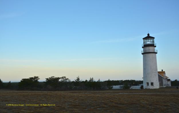
Image of Highland Light (Cape Cod Light) at dawn. Image credit: Karatzas Images
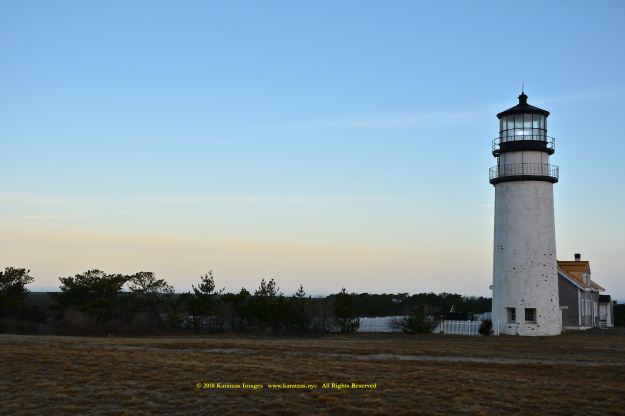
Image of Highland Light (Cape Cod Light) at dawn. Image credit: Karatzas Images
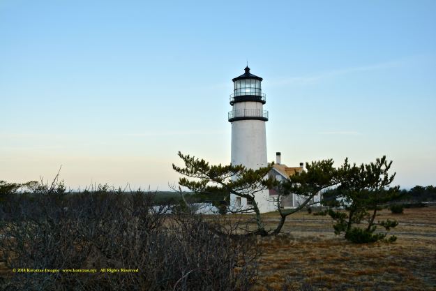
Image of Highland Light (Cape Cod Light) at dawn. Image credit: Karatzas Images
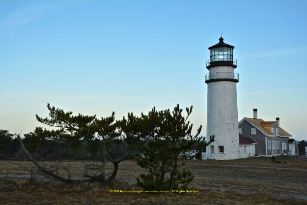
Image of Highland Light (Cape Cod Light) at dawn. Image credit: Karatzas Images

Image of Highland Light (Cape Cod Light) at dawn. Image credit: Karatzas Images

Image of Highland Light (Cape Cod Light) at dawn. Image credit: Karatzas Images
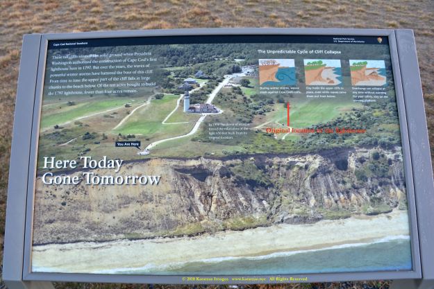
Visual depiction of the Highland Light (Cape Cod Light) with original and present location of the lighthouse indicated; cliff erosion is clearly visible. Image credit: Karatzas Images

Landmarks of the Highland Light (Cape Cod Light). Image credit: Karatzas Images   

Image of Highland Light (Cape Cod Light) at dawn. Image credit: Karatzas Images

Image of Highland Light (Cape Cod Light) at dawn. Image credit: Karatzas Images

Image of Highland Light (Cape Cod Light) at dawn. Image credit: Karatzas Images

© 2013 – present Basil M Karatzas & Karatzas Images. All Rights Reserved.

IMPORTANT DISCLAIMERS: The purpose of this blog is for entertainment and information purposes. Vessel description(s), if any, is/are provided in good faith and believed to be correct and accurate but no assurances, warranties or representations are made herewith. Any vessel description(s) is/are provided for entertainment purposes only. We assume no responsibility whatsoever for any errors / omissions in vessel description.

Access to this blog signifies the reader’s irrevocable acceptance of this disclaimer. No part of this blog can be reproduced by any means and under any circumstances, whatsoever, in whole or in part, without proper attribution or the consent of the copyright and trademark holders of this website. To purchase rights or merchandise of high resolutions images and art presented here, please visit www.karatzas.nyc or email < info [at] BMKaratzas.com >. Thank you for the consideration.

Akti Miaouli

When one hears the words “Fifth Avenue”, fine shopping springs to mind. “Fleet Street” stands for the British national press and “Madison Avenue” for advertising. There are many more metonymies for other industries and professions.

And, then, there is “Akti Miaouli”.

In all out travels, it never fails to amaze us the magic touch of the word, the matter of shipping companies managing thousands of merchant ships worldwide from Akti Miaouli, the sterling address of vessel managers from where remittances and paychecks for seafarers originate, the connotation of a gilded boulevard by the port where supernaturally rich shipowners have their family offices. Akti Miaouli stands to the world for Greek shipping.

There are reportedly close to one thousand Greek shipowners and vessel managers today based in Greece. Although only 1,350 merchant vessels worldwide fly the Greek flag (vs 7,900 and 5,400 vessels for the Panamanian and Japanese flags, respectively,) according to the most recent annual report of the United Nations Conference on Trade and Development (UNCTAD), Greek shipowners top the world list with ownership of 4,200 merchant vessels and a cumulative tonnage of 310 million deadweight (while world’s second biggest owner Japan owns 3,900 merchant vessels at 224 million deadweight.) Greece controls appr. 17% of the world’s merchant fleet.

For an island nation like Japan with a large population, heavy industry and shipbuilding and a robust financial system, one can understand the competitive synergies the country lays for a massive merchant fleet. Likewise, for countries with certain competitive advantages like ease of access to capital in the United States and Germany or an extensive coastline like in Indonesia or tax efficiencies like in Panama and Singapore or massive “state support” (loosely defined) in the People’s Republic of China, one can appreciate the reasons for these countries having a great number of merchant fleets.

But Greece? Besides its coastline (appr. 13,700 kilometers, almost as long as PRC’s 14,000 kilometers, but a fraction of Indonesia’s 54,800 kilometers,) Greece has no trade, no heavy industry (or industry at all, quite frankly,) a small population of eleven million people, no industrial shipbuilding, no substantial banks or financial institutions. Trying to analyze the industry and the business environment, an economics student would have a hard time to make the case in a college class paper that Greece could ever be a meaningful player in the world of merchant shipping.

Possibly the very same reasons that have prevented Greece from becoming a world power in modern history may have propelled the country in the world of shipping. There are 6,000 islands in Greece (but 18,000 islands in Indonesia’s Archipelago,) some of them no more than a rocky speck in the richly blue Aegean Sea where life is not easily sustainable; many islanders took to fishing and fishing boats and diving (famously for sponge in the Dodecanese) and costal ferries and then international merchant ships, as ratings at first and then officers and engineers and captains. Almost all Greek shipowners originate from the Greek islands, whether of the Aegean or the Ionian Seas, and almost none from the continental, mountainous Greek. They worked hard and sacrificed a lot and risked even more, and paid their dues to climb the learning curve and eventually start buying their own ships; some British rust buckets that were going for scrap in the 19th century, many more Liberty ships in the 20th century, and many many more newbuildings at the turn of the century.

As stated in previous blog, shipping and especially the drybulk market were the textbook example of what economists define perfect competition, and the shipping expertise and hard work served Greek shipowners very well. It’s not usual to meet today third and fourth and even fifth generation Greek shipowners, just as one sees shops and businesses in England and Germany established in the 18th and 19th centuries. Greek shipowners worked very hard and “added value” – as we would say today – to the world’s trade; of course, they benefited from circumstances – some legitimate but some questionable (at least by today’s standards), but they run ships cheaply and efficiently, the envy of the world. And, their “nose for the market” to time the market prudently to buy “cheap ships” in bad times and sell them at a multiple a few years later in better times only added to their reputation as shrewd people of the sea.

Akti Miaouli and the passenger Port of Piraeus, Greece. Image credit: Google maps.

It’s a miracle indeed seeing a group of business people from a small country reached such collective dominance. And no wonder that Akti Miaouli, carries such great connotations for the people of shipping worldwide. Just the east and south terminals of Piraeus’ main passenger port, with its own private club (Piraeus Marine Club) for dining and socializing, Akti Miaouli used to be where most of Greek shipowning companies were based by choice and for reputational reasons, sort of sign for “making it to the top”. There are buildings graced with names of the pillars of Greek shipping like Livanos and Lemos and Chandris and many more, and, in a sign of a truly competitive business and in-your-face attitude, the best real estate and prestigious buildings were close to the Church of St Nicholas, saint patron of seafarers and shipping; the closer to the church and the holy relics and the priest and the bishop, the closer to be to the center of things… Some religion or even superstition never heard anybody…

Like many industries in our age, the internet (and also other factors for Akti Miaouli) brought a diaspora of shipping companies from Akti Miaouli, whereby some moved to the northern and others to the southern suburbs of Athens. Akti Miaouli (meaning Miaouli Coast, Andreas Miaoulis being a Greek admiral and hero of the Greek War of Independence against the Ottoman Empire in the 19th century) is today a shadow of its old glory with only smaller shipping companies (and some service providers such as shipbrokers and adjusters and insurance agents) being still placed there.

As shipping keeps facing challenge after challenge after challenge in the last decade, some have been worrying about the state of Akti Miaouli. Yes, the shipowners of Akti Miaouli had been extremely graceful and managed to excel at handling the crises handed to them since WWII, but would the new market – where financiers opt for big corporate structures of a shipowner and charterers do differentiate in favor of big and modern fleets – still be a productive market?

I still remember like yesterday an experience from almost fifteen years ago on a cold, wet winter night with the deck lights glimmering in heavy fog, when I boarded an aframax tanker in Lake Charles, LA as a husbandry agent; the Filipino able man standing guard at the gangway, upon learning that I was originally from Greece, started asking magical questions about Akti Miaouli (where the management of the tanker and his paycheck was coming from); as almost Akti Miaouli was some sort of Shangri-La and Promised Land together, a place from where the world’s merchant fleet was transcended to the seven seas and where the streets were lined up with treasure caskets.

Ready to dock at Akti Miaouli, Piraeus. Image credit: Karatzas Images


© 2017 to present.  All Right Reserved. Karatzas Marine Advisors & Co.

IMPORTANT DISCLAIMERS:  Vessel descriptions (if any) are provided in good faith and believed to be correct and accurate but no assurances, warranties or representations are made herewith. Vessel descriptions (if any) are provided for entertainment  purposes only. We have no responsibility whatsoever for any errors / omissions in vessel description.                                                                                                                                                                                                   Access to this blog signifies the reader’s irrevocable acceptance of this disclaimer. No part of this blog can be reproduced by any means and under any circumstances, whatsoever, in whole or in part, without proper attribution or the consent of the copyright and trademark holders of this website. Whilst every effort has been made to ensure that information herewithin has been received from sources believed to be reliable and such information is believed to be accurate at the time of publishing, no warranties or assurances whatsoever are made in reference to accuracy or completeness of said information, and no liability whatsoever will be accepted for taking or failing to take any action upon any information contained in any part of this website.  Thank you for the consideration.

China’s Maritime History and Admiral Zheng He’s Treasure Ships

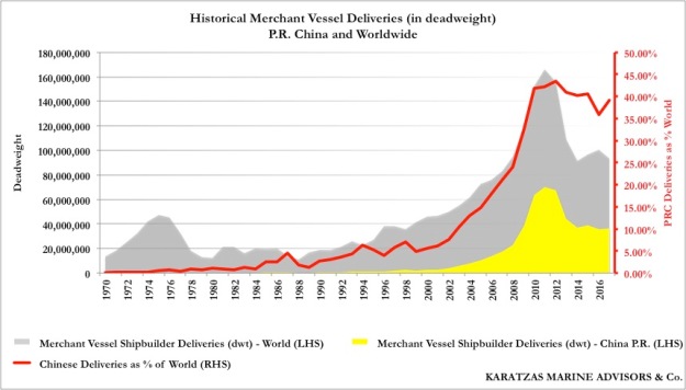
In the last fifteen years, China has made an impressive entrance to the international maritime scene. From chartering and trading to vessel ownership and shipbuilding, China has captured a substantial worldwide market share. As an example, in the following graph, in the newbuilding industry, its worldwide market share by deadweight of newbuilding deliveries went from negligible at the turn of the century to appr. 20% a decade ago and now stands at 40%.

Historical newbuilding deliveries, China (PRC) and world, market share. Graph credit: Karatzas Marine Advisors

To the casual observer, it would seem that the maritime industry is just another industry where China has started dominating the market given some competitive advantage; that China saw a business opportunity in this industry and they just moved in. If clothing and manufacturing for everyday articles can now take place in China, why not for ships?

However, for shipping, one can say that China has had a time-honored relation with the seas and the waters, inland and its two huge rivers, coastal and also ocean navigation. As a short proof for that, one can be reminded that Chinese invented the compass approximately around 200 BC during the Han Dynasty, allowing for the first time ships to navigate away from the coast. Chinese first invented the dry-dock in the tenth century AD, while dry-docks were introduced to European shipbuilding in the late fifteen-century in Portsmouth, England[i]. Similarly, the concept of building ships with watertight compartments (bulkheads) is attributed to shipbuilders of the Ming Dynasty based on their observations that bamboo trees are light and hollow inside and are made of the isolated chambers in the trunk. Only if the shipbuilders of the RMS Titanic had paid closer attention to such seemingly irrelevant observation! 

The Treasure Ships

The Chinese historic navigational achievements that is known in the West are the Treasure Ships of the eunuch Admiral Zheng He who in 1418, in the early Ming Dynasty, reached the east coast of Africa (at Malindi, in today’s Kenya) with an estimated fleet of three hundred boats consisting of vessels as large as four-hundred-foot long with nine-masts (bao chuan or treasure ships) and manned with 28,000 sailors.

The Portuguese explorer Vasco de Gama landed on the east African coast in 1498, seventy years after Zheng He’s landing, the first European to reach these parts of the world; de Gama, upon his arrival in east Africa, was regaled by village elders with tales of white “ghosts” of ships with silk sails that had reached their shores several decades earlier.

The treasure ships had watertight bulwark compartments, a Chinese innovation, a stern post and a “balanced” rudder position forward of the stern post, both Chinese naval innovations that were not introduced in the west until many centuries later. The vessels had nine masts and were square-rigged and brightly painted hulls. They had “dragon eyes” on the prow and phoenix patterns on the hull for auspiciousness, the underwater part of the hull was whitewashed and the waterline was painted red with a sun-and-moon frieze. Although treasure ships were equipped with canons, they were primarily intended for luxurious accommodations, literally and figuratively, acting as the flagships of the fleet. The treasure ships were a handful in the fleet, which was dominated by the presence of “horse ships” (eight-masted, some 339 ft long) to carry horses for trading, “supply ships” (seven-masted, some 257 ft long) for food and provisions for the 28,000 crews of the fleet, and “troop transport” ships (six-masted, some 220 ft long) carrying soldiers. In addition, there were escort ships, warships, patrol boats, even tanker boats for the provision of fresh water. Communications at sea among the fleet vessels was via an elaborate system of sight and sound signals, while “teachers who know foreign books” – translators – (tong yi fan shu jiao yu guan) were onboard to facilitate communications with other peoples.

Between 1403 and 1407 under the instruction of the Yongle emperor, 1,681 ocean-going vessels were built at the Suzhou shipyards and Longjiang. Vessels were also built at shipyards in the provinces of Jiangsu, Jiangxi, Zhejiang, Hunan and Guangdong. It is estimated that between twenty and thirty thousand people were living and working in the shipyards at the time as carpenters, ironsmiths, caulkers, sail and rope makers.

The treasure ships (bao chuan) or dragon boats (long chuan) of Admiral Zheng He were a combination of previous ship designs of shachuan (sandboats with flattened hull bottom) and fuchuan vessels (dragon ships with a deep keel, partially resembling that of a sailboat); and these treasure ships were grandiose in scale: “44 zhang 4 chi long and 18 zhang wide.” There is a historical discrepancy in terms of the exact size of the vessels, but present estimates place the vessels at approx. 390-408 ft. long and 160-166 ft. wide. In modern terms, such a vessel would have been too big to pass through the old Panama Canal locks, which until a couple of years ago was an industry standard. The dimensions of the treasure ships “444” were symbolic and lucky, four being the symbol of the Earth and its four “corners.” There were four “seas,” four cardinal directions, four seasons, and according to Confucianism, four bonds or virtues (si wei): propriety, integrity, righteousness and modesty.

The scale of the treasure ships was monumental but not unheard of: the ke zhou (guest ships) of the Song Emperor Huizong were 10 zhang long and the shen zhou (spirit ships) for emissarial missions were 30 zhang long; Tang Dynasty ships were 20 zhang long. Ships that Khubilai Khan built had ten sails and could accommodate 1,000 people. For riverboats, during the Song Dynasty, Xihu zhou chuan (West Lake Ships) were longer than 50 zhang.

While the sheer dimensions of the treasure ships draw our awe today, one has to wonder about the ability of the Ming Dynasty to logistically support such tremendous and elaborate expeditions. As Admiral Zheng He’s last expeditions required close to 30,000 crew, one has to wonder about the planning and ability to support so many people living in the open seas for months at a time, properly provisioned for, managed and led. Several centuries later, building just a ship of war with eight hundred (800) crew was known to be a major undertaking for any king when Britain ruled the waves.

The admiral and captain aboard the treasure fleet were appointed individually by the emperor and were empowered with the right to “kill or let alive.” Unlike the expeditions of Vasco de Gama and Christopher Columbus that involved a handful of small caravels, the treasure ship expedition resembled an autonomous, magnificent force with the intent to explore and trade, but also to impress and convey the power of the emperor in the early Ming Dynasty.

Ships in China prior to the Ming Dynasty

Starting from the Yin people in China, and the Han Empire later, Chinese built lou chuan (castle or deck ships), navy ships with oarsmen believed to resemble ancient Greek triremes; there were also qiao chuan (bridge ships), navy ships that were used as fighting platforms for men and horses. As early as in the early centuries A.D., the Chinese were aware of basic principles of winds and currents in the Pacific Ocean, and there is historical evidence of shipbuilding in the coastal provinces of Guangdong, Fujian and Zhejiang since the Han Dynasty. In the Tang Empire, Chang’an was established as a mighty metropolis by the Yellow River in north China. However, with active trade with regions in the Indian Ocean such as sandalwood from India and Java, frankincense from Somalia, dates and pistachio nuts from Persia, black pepper from Burma, and the spice ports of Malaya and Sumatra; the Indian Ocean, in general, was an active link for trading China’s porcelain just as overland routes were critical for the silk trading. The Chinese, via the spice ports in the Indian Ocean in the Tang Dynasty, were indirectly exposed to the Persian cultures since the latter was reaching these same ports in the Indian Ocean with their Ceylonese ships (triangular lateen ships). Hence, active trade was during that time that the Bureau of Merchant Shipping was established in the eighth century in Guangzhou to ensure for proper taxation and avoidance of contraband. Around the same time, the Grand Canal was completed linking the north and south and facilitating international trade via the Central Asian Silk Route. River navigation was so active then that during storms in 721 and 751, it was reported that more than 1,000 boats were destroyed on each instance.

In the Song Dynasty, so-called “sea falcon vessels” were developed, mostly for inland and river navigation; these vessels had a flat bottom and floating leeboards in the shape of a bird’s wings that offered stability and could also be used to navigate the vessel. Improved versions of these vessels had paddle-wheels (probably another Chinese invention.) Navy ships (“flying tiger warships”) had eight wheels that were powered by forty men on treadmills allowing for the vessels to navigate smoothly on the water “like a dragon” and instilling fear in the enemy with their appearance and maneuverability. When gunpowder was invented, these naval ships in the Song Dynasty were the first to utilize gun powder onboard when fighting the enemy.

Ships that were first built at Longjiang to travel from China to Korea in the shallow Yellow Sea during this period were known as shachuan (sandboats) that had flat bottoms to prevent them from sticking in the sand (fang sha ping di chuan, or “flat-bottom-boat-that-prevents-running-into-the sand). However, such vessels were not suitable sailing in the open seas. Shipwrights from the Fujian developed a new technique for a V-shaped hull with a deep keel “sharp like a knife” that could cut through big waves. These fuchuan vessels had four decks, four masts, nine sails, a crew of 250 to 300 sailors, and the prow and the stern were positioned high above the waves. While the deep keel of a fuchuan vessel was referred to as the “dragon bone,” the prow brought the anthropomorphic feature of eyes (“dragon eyes”) so that the vessels could “see” where they were heading.

When the Dragon Throne Met the West

The treasure fleet of Admiral Zheng He and the small fleet of the explorer Vasco de Gama never met in Africa, outside China, although Vasco de Gama got to see for himself China’s fading maritime prowess when he eventually reached mainland China. From a philosophical point of view, however, these are several interesting questions to ponder that could had affected the course of history. Had Vasco de Gama’s and Zheng He’s fleets met in Africa in the early 15th century, would Vasco de Gama and the Europeans simply be intimidated by the strength of the Chinese fleet (hundreds of vessels for a Chinese vs. three battered caravels for the Europeans)? Would the size of the Chinese vessels (approximately five times longer and with nine masts) forced the Europeans to never attempt sail eastwards out of sheer fear of the unknown empire east threaten the Europeans? Would He had been tempted to destroy de Gama’s fleet, and possibly delay at the very least for decades or centuries, Europe’s reach to China? Irrespective of what may had happened if the two fleets had met, Chinese naval superiority at that time was unquestionable, the result of constant progress in trade and engineering in Ming China.

[ii] Ebrey, Patricia Bukley, China Cambridge Illustrated History, 2nd Edition, 2010; p120


IMPORTANT DISCLAIMERS:  Vessel descriptions (if any) are provided in good faith and believed to be correct and accurate but no assurances, warranties or representations are made herewith. Vessel descriptions (if any) are provided for entertainment  purposes only. We have no responsibility whatsoever for any errors / omissions in vessel description.

Access to this blog signifies the reader’s irrevocable acceptance of this disclaimer. No part of this blog can be reproduced by any means and under any circumstances, whatsoever, in whole or in part, without proper attribution or the consent of the copyright and trademark holders of this website. Whilst every effort has been made to ensure that information herewithin has been received from sources believed to be reliable and such information is believed to be accurate at the time of publishing, no warranties or assurances whatsoever are made in reference to accuracy or completeness of said information, and no liability whatsoever will be accepted for taking or failing to take any action upon any information contained in any part of this website.  Thank you for the consideration.